By Jason Vogel and Allyn Feinberg, Indian Peaks Traverse Coalition
We write today as members of a grassroots organization promoting a non-motorized, back country trail from Boulder to Winter Park. We call this proposed trail the Indian Peaks Traverse (IPT) and we recently incorporated as a 501(c)(3) not-for profit corporation to support the concept and the land management agencies that will be crucial to realizing this vision. We are a group of optimistic Boulder County and Grand County citizens who love adventure, history, conservation, and recreation.
The final missing link of the IPT, from Eldorado Canyon to Walker Ranch (the “Eldo-to-Walker” trail), is under consideration by a three-agency working group, with a final decision expected in March 2019. The agencies are Boulder County, the City of Boulder and Colorado Parks and Wildlife. Details about the Eldorado Canyon to Walker Ranch Connection Feasibility Study can be found on the county’s website.
We wanted to weigh in with some thoughts about where we stand and how to move forward in support of getting to yes on this critical final link.
There is a lot of enthusiasm about building a multi-use trail from Eldorado Canyon State Park to Boulder County’s Walker Ranch and the enthusiasm is understandable. This connection has been discussed for a very long time—it varies from 5 years to 15 years to 29 years depending on whom you talk to. Any way you slice it, this regional trail opportunity has been through the most thorough vetting process of any trail that we are aware of. A consulting team of ERO Resources Corporation and Contour Logic has been assessing the feasibility of multiple Eldo-to-Walker routes under careful supervision by all three agencies since 2014.
The enthusiasm is also due to the high expectations for this trail. For example, the City of Boulder Open Space and Mountain Parks Department (OSMP), in their 2011 West Trail Study Area Plan, identified Eldo-to-Walker as one of only two trails in that area that mountain bikes should get access to (Chapman Drive was the other).
And, Boulder County Parks and Open Space (BCPOS) also identified Eldo-to-Walker as a regional trail worth pursuing in its 2013 Walker Ranch Management Plan update. In that plan, Boulder County went so far as to suggest extending the regional trail to the west across the burn area and Tom Davis Gulch to connect with the Gross Reservoir Road.
These two documents (the OSMP area plan and the BCPOS management plan) have provided the management direction that makes the IPT possible. Following their staff’s recommendations, both the Boulder City Council and the Boulder County Commissioners approved recommendations to explore this trail. So a big “thank you” to the agencies for working over such a long period of time to make the IPT possible!
On top of the local support, Eldo-to-Walker was selected by Governor John Hickenlooper and his administration as one of the “the Colorado 16” (16 in 2016) priority regional trails in the 2016-2026 Colorado State Trails Plan and in the Colorado Department of Natural Resources Colorado the Beautiful Program. Understandably, this support at the state level has added to the enthusiasm.
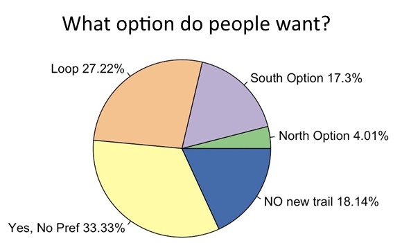
Of the 450 public comments on the Eldo-to-Walker trail received by the agencies, 86.2% of respondents were supportive of a trail and 13.8% were against. This is a pretty compelling majority. Of the 450 respondents, 261 were primarily mountain bikers, and, not surprisingly, not one was against the trail. Of the 94 self-identified hikers, 65.6% favored the trail.
What we find more interesting, however, is that a majority of respondents who do want a trail express an alignment preference (advocating for either a north or a south alignment or for a loop). Of bikers, 59.8% express a preference. And of hikers who support a trail, 65.9% express a preference. But in our opinion, the evidence to select one option over another is pretty thin. The county has not yet published the consultant’s report, we have not heard significant testimony from staff or the consultants on the various qualities of the different alignments, and the public has not been allowed to tour the alignments themselves (with a few exceptions).
We consider ourselves engaged but neutral observers of the debate over north versus south—either alignment would allow for the IPT to exist, as we stated in our organizational response to the county’s call for public comments. But we do have a number of concerns that we feel need to be addressed in order to intelligently select between the north and south alignments. And surprisingly, very few of these issues appear to be part of the conversation so far—at least publicly. So perhaps it’s time to put some of these issues on the table since we believe they are so crucial.
- What are the ecological concerns around the north and south alignments? We have heard that there may be some opposition to the south alignment related to ecological concerns, but very few people have any real knowledge of the area and its resources. It will be important to develop more information on this alignment. If there are significant ecological concerns for either/both alignments, it is absolutely necessary that such information be shared with the public. It is our experience that the majority of Boulder citizens and outdoor enthusiasts alike respect the environment and would not willingly advocate for an environmentally harmful option. Hopefully, we will see this information in the consultant’s report and staff’s analysis as well.
- How can we minimize user conflict in the first mile or so of either alignment? Both alignments would climb from the canyon floor very steeply, one on a proposed new alignment and the other on the old Rattlesnake Gulch Trail. Based on our own anecdotal research, the speed of mountain bikers heading downhill, especially given the observed and likely demographics of hikers on either trail (tourists, families with kids, and other non-expert trail users) creates a situation ripe for user conflict. However, the likely solutions on the north and south alignments will be different (reconstructing Rattlesnake Gulch versus perhaps separated use of two trail alignments). It is critical that this conversation be included as part of the decision on which alignment should move forward so we don’t select a trail doomed to fail.
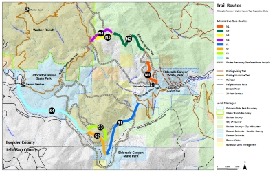
- Can we make Eldo-to-Walker a good regional trail connector? The current south alignment climbs steeply up the canyon on the old Rattlesnake Trail, then meanders a long distance and ends up at the top of the BCPOS Crescent Meadows trail head at Walker Ranch. The north alignment also currently climbs steeply up the canyon and then heads toward Walker Ranch. Unfortunately, this trail then drops almost the full vertical distance back down to South Boulder Creek along the existing Eldorado Canyon Trail, very far from the nearest trail head. It appears that alignments to extend this trail to the Ethel Harrold trail head were previously considered, but were dismissed by staff. We’d like to understand more about the tradeoffs here. If the north alignment is chosen, we believe the functionality of Eldo-to-Walker as part of the regional IPT would be greatly enhanced if the trail headed to the Ethel Harrold trail head instead of dropping back down to South Boulder Creek. Read an anecdote about this out-of-your way trail segment here.
- How will trail users get east/west through Eldorado Canyon State Park? This issue is perhaps the most crucial of them all. In our conversations with state park staff, they are clearly concerned about use conflict, crowding, and safety on the road going through the park. But again, the solutions to this issue may look very different for the north versus south alignments. A north alignment may require construction of a brand new “creek side” trail, which may be a great thing for the state park, but could be costly. Conversely, an off-road connection on the south side already exists, but would require opening the Fowler Trail and Goshawk Ridge Trail to mountain bikes. Which of these ideas is more feasible? What are the tradeoffs? We hope this issue can also be addressed as part of the Eldo-to-Walker assessment.
In summary, neither the public nor the IPT Coalition has yet received enough information to constructively engage in a discussion of whether the north side or south side trail alignment makes more sense. We encourage BCPOS, OSMP, and Eldorado Canyon State Park to provide more information and to address our questions. This will help us assess which trail alignment is more feasible given all management objectives (i.e., minimizing ecological impacts, reducing conflict, providing a high quality trail experience, ensuring the trail can effectively connect to other trails to avoid parking and crowding issues in Eldorado Canyon State Park, and facilitating regional trail connectivity, among others).
We are hopeful that the consultant report and staff’s analysis will provide answers to these important questions. And if it doesn’t, we hope that staff will consider these critical issues in a meaningful way so we as a community can choose an alignment with the best chance of success in both the near- and long-term.


 (12 votes, average: 4.67 out of 5)