Two related occurrences—a proposal to build a massive berm to control flood waters and reconsideration of land use designations as part of the current Boulder Valley Comprehensive Plan update process likely leading to an annexation application—will probably cause significant changes at the University of Colorado south campus in the next few years. Moreover, over the long term CU’s plans would transform the current character of the property. Those were the general conclusions of a PLAN-Boulder County forum on December 16, 2016, about the future of the south campus.

CU south campus looking west from the south edge (image from Ellis presentation)
At the forum, panelists Lesli Ellis, comprehensive planning manager for the city; Kurt Bauer, engineering project manager for the city; Ben Binder, a community activist, registered professional engineer and registered land surveyor; and Frances Draper, vice chancellor for strategic relations at CU each made formal presentations and then discussed various sub-topics among themselves and with audience members. The content of the forum overlapped to some extent that of a community meeting which the city hosted on December 5 at a building on CU’s East Campus.
The south campus is a 308-acre parcel south of US 36 and Table Mesa Drive and east of the city’s Majestic Heights neighborhood. South Boulder Creek flows just to the east and south of it, and originally much of the land was in the South Boulder Creek flood plain. In the Boulder Valley Comprehensive Plan it is categorized as part of Area II—eligible for annexation.
The parcel was purchased in 1981 by Western Mobile for $250,000 and operated as a sand and gravel mine. City and county officials had always expected that when the mine was depleted the property would become a public park and/or open space. However, in 1996 Western Mobile stunned the city and many of its citizens by selling the mined-out land to CU for $16.4 million—$5.4 million of which was considered a tax-deductible gift to CU. As Binder pointed out in his presentation, Flatirons itself provided the appraisal which formed the basis of the $16.4 sale price. The city’s appraisal of the value of the property never exceeded $9.2 million.
To date, development at the south campus has been limited to tennis courts; and the public has been allowed free access to the property for recreation, including dog-walking. Many citizens have come to rely on this site for their exercise. In its long-range plans, CU had not shown any further development on the property; and for at least a decade conservationists seemed to have reason to hope that the parcel would remain de facto open space indefinitely. Those hopes have now been dashed.
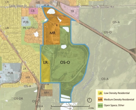
The Boulder Valley Comprehensive Plan is revised every five years, and it is currently undergoing such a revision. About 220 acres of the south campus is currently designated OS-Other (land that the city and county would like to preserve as open space) with the remainder designated MDR (medium-density residential) or LDR (low-density residential). Ellis said that under normal procedures the land uses would have been considered for redesignation during the past two or three BVCP revisions. But early in this century the Boulder City Council and the Boulder Planning Board declared that they should not be considered for re-designation until a South Boulder Creek flood mitigation study was conducted.
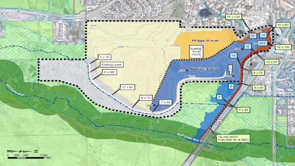
Bauer said that the latest study was started in 2010 and finished in 2015 with approvals from the Water Resources Advisory Board, the Open Space and Mountain Parks Board of Trustees, and the Boulder City Council. The study, Bauer explained, examined seven alternative schemes to control flood water from South Boulder Creek and concluded that the best design would feature a massive berm starting at the west bank of South Boulder Creek, paralleling the south sides of US 36 and Table Mesa Drive and then curling south and slightly east close to the Bridgewalk apartment complex (which is owned by the Boulder Housing Authority). Some of it would lie on CDOT right-of-way and some on CU’s property. Flood waters would be detained on about 80 acres on the south part of the south campus.
At its highest, the berm would be 29.5 feet tall. The top of the berm would be 15 feet wide and accommodate a multi-use path. As part of the plan, the flood detention area will be excavated and fill will be added to some of the land on the west side of the south campus. The scheme is estimated to cost about $22.5 million. Bauer said that the city’s flood utility expects to fund the project in 2018. Once approved, it would take about a year to fully design and then about two years to construct.
Ellis declared that discussions will occur on the Open Space and Mountain Parks Board, the Planning Board and City Council in January about re-designation of the current land uses at the south campus. She expects the staff to issue a draft recommendation in March.
Draper revealed that in the next several years CU wants to add more athletic fields to the South Campus, as well as locker rooms with showers, rest rooms and drinking fountains for athletes and spectators. Those facilities will require water, which only the city is in a position to provide.
In the long-term, she said that CU is interested in using the site for faculty and staff housing, lodgings for graduate students and upper division undergraduates, and academic, instructional and research facilities. She said it will not build a football stadium, tall towers, lodgings for freshman, nor a by-pass from 47th Street to Highway 93 there. She claimed that CU intends to reserve about 80 acres for flood water impoundment and about another 80 acres for open space.
Draper asserted that CU wants to have the whole property annexed at once to save on administrative and legal costs. She also emphasized that the construction of major facilities at CU involves a lengthy and laborious process that requires approvals from various levels of the university hierarchy and state government agencies.
Binder reviewed some of the history of the South Campus property. He pointed out that the current 6,000 foot long berm which curves around the eastern side of the property has the effect of expanding the 100 year flood plain immediately to the south of US 36 and then also to the north of that highway beyond what it would be without the berm.
The current berm was originally built by Western Mobile as a “temporary” structure to protect its mining operations from a flood. However, when mining ceased, the company and CU applied to amend the approved reclamation plan for the property so that the berm would become permanent and five planned ponds covering 38.1 acres of surface would be reduced to two ponds covering 4.2 acres. Binder displayed copies of documents indicating that the purpose of these changes was to increase the amount of developable land on the parcel.
Nationally renowned CU geology professor and flood expert Gilbert White wrote a letter expressing concern that the revised reclamation plan would increase the flood hazard downstream. Nevertheless, Western Mobile and CU persuaded state and federal authorities to allow the berm on a permanent basis, and the five planned ponds were decreased to two.
Binder also showed photos of wetlands being bulldozed after CU took possession of the property. He documented the installation of underground, aggregate drains by the university in 2001, which he contended were intended to lower the water table and drain parts of the campus.
Binder commented that the flood mitigation plan preferred by the city’s study seems to be designed to maximize the amount of developable acreage on the south campus. Indeed, the information which Bauer presented indicated that of the seven schemes considered the one which was chosen had the next to lowest impact on the land area within the south campus.
Binder argued that the city’s flood plan is overly complicated and would move the flood water along a circuitous route. He proposed an alternative plan which he claimed is simpler and more natural. Under Binder’s proposal, flood water would be diverted to the south end of the south campus and impounded by a series of three berms. But he readily allowed that the amount of developable acreage within the south campus would be reduced under his plan.
The audiences at both the PLAN-Boulder forum on December 16 and the city-sponsored meeting on December 5 were large and filled with many residents of southeast Boulder, including a vocal contingent from Frasier Meadows Manor, who expressed great distress at the prospect of another flood inundating their neighborhoods, such as happened in 2013.
View the panelists’ presentations: Ellis-BVCP, Bauer-flood control, Draper-CU, Binder-community activist


