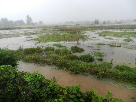
The northern end of the Hogan-Pancost property on the morning of Sept. 12, 2013 (photo from http://ramadda.org/repository/entry/show?entryid=27d13820-6805-4912-b096-370cf97c376e)
At a PLAN-Boulder County forum on Friday, December 4, 2015 about the status of the Hogan-Pancost property, Jeff McWhirter, president of the Southeast Boulder Neighborhood Alliances (“SEBNA”) asserted that the risk of catastrophic flooding on that parcel, though likely significant, is now too poorly understood to justify its annexation and future development.
McWhirter claimed that, because of flood risks and high water tables, the city never should have allowed development of the Keewaydin Meadows and Greenbelt Meadows neighborhoods, which are situated just to the west of the Hogan-Pancost property. Permitting development of Hogan-Pancost would serve to compound those earlier blunders, he implied.
He declared that the primary criterion of the city in considering development proposals should be “Don’t cause harm.” But he claimed that the city staff has not really tried to assess the flood hazard at Hogan-Pancost.
Hogan-Pancost is a 22-acre piece of land that lies south and west of the East Boulder Community City near South Boulder Creek. The land was traditionally used for pasture, and McWhirter said the agricultural owners usually irrigated it by flooding it. However, at some point in the early part of this millennium it was purchased by a group of local investors, which included Mike Boyers, Lou Della Cava, Woody Eaton, and Gary Myre and called itself Boulder Creek Commons, LLC., for a price often believed to be $4.5 million.
Hogan-Pancost is not located within the city limits. It has been designated as Area IIA in the Boulder Valley Comprehensive Plan, which means that it is eligible for annexation. As part of the regular, 5-year update of the Boulder Valley Comprehensive Plan, SEBNA filed an application to re-designate the parcel as Area III, which would make it ineligible for annexation. McWhirter said that unsuccessful requests by citizens groups to re-designate the property as Area III had also been made in 2005 and 2010.
Around 2011, Boulder Creek Commons proposed annexation of Hogan-Pancost and a 130 dwelling unit development on it. In 2012, six of the seven Planning Board members expressed support for the concept plan for the proposed development. However, in 2013, after 18 hours of hearings and extensive expert testimony, the Board unanimously rejected the proposal.
The current county zoning applicable to Hogan-Pancost allows two houses to be built there.
McWhirter cautioned that re-designation of a parcel under the BVCP is difficult because it must be approved by each of four bodies: the Boulder County Commissioners, the Boulder County Planning Commission, the Boulder City Council and the Boulder City Planning Board.
McWhirter recounted that over the decades Hogan-Pancost has been subject to intermittent floods, the first of which was recorded in 1938. Its water table is only 10 inches below the surface, he said. Its west side lies in the high hazard flood zone, he observed; and the development proposal of Boulder Creek Commons contained a plan to raise the grade of the parcel by one to four feet using fill dirt.
The Dry Creek Ditch No. 2 runs along the western edge of the property. McWhirter said that that ditch follows the alluvial flood channel of South Boulder Creek. In the September, 2013, flood, McWhirter noted that flood waters topped U.S. 36 at the point where it crosses the ditch. In the event of a major flood, McWhirter asserted that the ditch would not be capable of carrying much of the water, which would spill over its banks and inundate the surrounding land.
McWhirter castigated the city staff for failing to try to predict the amount of water that would pour through this area in a major flood. He said that it tends to rely on the reports of consultants, which are typically hired by developers, rather than attempting serious study of the subject itself. He claimed that the city’s planning staff had never asked the leading flood expert in the city’s utilities division to opine on the flood hazards at Hogan-Pancost.
McWhirter pointed to a host of other problems if the property were to be annexed and developed more intensively than currently allowed by county zoning. Due to the weight of more fill-dirt on the west side of the property, the water table under nearby, existing residences would probably rise and their basements would flood more often than currently occurs. The densest habit in the world for the Preble’s meadow jumping mouse, an endangered species, extends along the South Boulder Creek channel just to the east of Hogan-Pancost. Development could well threaten the mouse’s habitat. (McWhirter lamented that the Open Space Department’s resident Preble’s mouse expert had not been asked by city planners to assess the effect of Boulder Creek Commons’ proposal on the creature). He added that the northern spotted leopard frog, a “species of concern,” lives in the area and might be jeopardized by development.
McWhirter also contended that motor vehicular traffic in the existing residential neighborhoods around Hogan-Pancost would be significantly increased if the property were developed at close to the intensity proposed by Boulder Creek Commons.
McWhirter cited various environmental and other provisions of the BVCP in support of his contentions that Hogan-Pancost should not be developed beyond its current zoning limit.
He said that about 30 other applications to re-designate parcels under the BVCP have been submitted. The Boulder County Commissioners and the Boulder County Planning Commission will start to consider all of them in January, 2016, he said. Then the Boulder City Council and Boulder City Planning Board will review them in February.
A lawyer representing Boulder Creek Commons attended the talk as a member of the audience, but chose not to speak. However, after the meeting he distributed a written statement from the company to all those who were receptive.


